Various boat projects and ideas related to boating in general. Feel free to contribute your project. We are looking for the unusual; the new or different technique; or boat improvement project or product that others may find useful. Please email us at solaceadventures at gmail dot com to tell us about something you might have, to put on our blog site. Please, limit your comments to the subject or item(s) discussed. Businesses posting, that don't adhere to this, will be deleted.
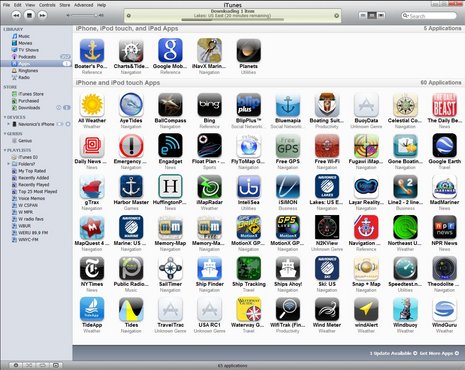
While gathering up (purchasing the required items) for my ipad, to add to the boat, I came across this piece of information from Latitude 38 Magazine. (They have an on line version as well as a PDF version of their published magazine.) It is a story about using your iPad as a hotspot for up to five other devices. Hop over to their story and get the full text. I haven't purchased my iPad yet and was unaware of this feature. But I certainly hope to use it. Any way, Latitude 38 goes on to state, "Just go to the main TelCel office, replace your U.S. SIM card with a Mexican SIM card, and your iPad becomes a 'hot spot' — meaning that up to five other nearby devices can wirelessly use it for internet access also." Of course this all depends on whether your carrier supports it. For instance, in the USA, Verizon includes the hot-spot feature with the iPad data plans, while AT&T doesn't support it. This has distinct advantages for us, because we carry a PC, a Mac, and soon to be added, an iPad. We use to use a cell phone modem that could connect up to five devices also. I liked it a lot because we never had to plug it into a computer to get a connection. We had two, from two different carriers because of the different reception coverage areas. But I was also thinking about the iMux I bought. It can only connect one device at a time. And so I was wondering if I can connect with the iPad to the iMux when underway, and stream the data to other devices, such as my PC which also has charting software?? I will write a blog later in 2013 about how I set up my iMux, iPad, and iNavX. Till then, those with an iPad can follow these instructions for setup. Follow this link to get the low down of how to set up your Hotspot or follow this Tap Settings > General > Cellular Data:
Tap Personal Hotspot and turn it on:
After configuring Personal Hotspot, you can directly access the settings from Settings > Personal Hotspot.
Seatalk is Raymarine's proprietary communication "language" for interconnecting Raymarine instruments.Unfortunately Raymarine keeps the technical details of Seatalk secret and so the nitty critty of the system often has to be reversed engineered if designing something to work with Ray's different seatalk buses. However, most of you out there just want a plug and play system and I can say that Raymarine has done a pretty good job of that.
Raymarine has produced four communications protocols featuring SeaTalk as the root of the protocol's name. These include:
SeaTalk (also referred to as SeaTalk1 or first generation SeaTalk)
SeaTalk2
SeaTalkng
SeaTalkhs
Seatalk to nmea0183 and RS232
SeaTalk/Seatalk1 Seatalk is the same as seatalk1. Ray just added the 1 after developing other more modern buses that they called seatalk2, seatalk hs and seatalk ng. Seatalk1 is ray's propriety version of nmea 0183. Seatalk1 is readily able to be converted to nmea 0183. Raymarine supply an accessory (Part #E85001) for converting Seatalk to NMEA 0183. Also, ShipModul's and Brookhouse's MUXes also convert Seatalk to NMEA 0183. Alternatively, if you have the ST60 repeater, you will find a NMEA output on the device which can connect directly to a SOB COM port. Seatalk which is often referred to now, as seatalk1, is a multi-talker, multi-listener approach using serial data at low data rates (4.8Kbps). Compare that to nmea 0183 which is predominately a single talker, multi listener unless one uses a multiplexer. The network used proprietary cables and connectors that were designed for the marine environment. The connectors are three pin molded and incorporate 1/8” automotive spades as mating elements.
Seatalk cable
The network could be implemented as either a simple daisy chain structure or the more robust approaches of backbone, spur or star design. SeaTalk uses three wires, connected in parallel to all devices on the bus:
+12V Supply, red
GND Supply, grey
Data Serial Data, yellow
There is no master on the bus. Every device has equal rights and is allowed to talk as soon as it recognizes the bus to be idle (+12V for at least 10/4800 seconds). Low priority messages use a longer or randomly selected idle-bus-waiting-time. This allows messages from other devices with a higher priority to be transmitted first. The different waiting times of all devices make data collisions (two or more devices start talking at exactly the same moment) very rare.
Unlike the Seatalk2 and Seatalk ng communications protocols, Seatalk communications protocol does not feature termination. Any Seatalk instruments and instruments or autopilot components featuring a 1st generation Seatalk interface which does not have a Seatalk ng interface (ex. ST40/60+ Instrument Displays, ST6001, etc.) can be interfaced to one another, in any order, using standard Seatalk cable. Seatalk cables can be joined using a Seatalk Junction Block, splices, marine grade terminal strips, or R55006 Seatalk Auxiliary Junction Boxes. This method of interfacing is referred to as a Seatalk bus. The Seatalk bus will typically be powered via a Seatalk Auxiliary Junction Box or via a Seatalk power cable which has been connected to one of the Seatalk devices. SeaTalkhs
Seatalk hs is raymarines high speed version of ethernet. It is plug and play.
By using SeaTalk hs networking, you can instantly transfer radar, chartplotter, fishfinder, thermal imaging and navigation functions. Configuring your system is a simple as determining which SeaTalk hs devices you'd like to have (chart, radar, sonar, video) and where you would like to see them.
The most basic system may consist of a C Series Widescreen or an E Series Widescreen with a DSM30, DSM300 or a radar. The components are all auto sensing, there is no complicated setup required. Simply plug them in.
E series integrates nmea 0183, 2000 and seatalk hs
Raymarine E-Series can input/output data via good old NMEA 0183, Seatalk (Ray’s proprietary improvement on 0183), Seatalk2 (sort of NMEA 2000 but seatalk ng is the bus that mimic's nmea 2000), and Seatalk HS (actually Ethernet). Plus the E’s (and C’s) do something called data bridging where they take data from one bus and put it onto another bus.
Raymarine has network switches when working between 3 to 8 devices. They are.......
HS-5
The new HS-5 Seatalk hs Network Switch which has five ports
Seatalk hs Network Switch which has 8 ports.
The following devices have Seatalk hs connections and can be easily connected together via the Seatalk hs network switch and Seatalk hs network cables:
Seatalk 2 is a five conductor system that has some N2K functionality. This network does require terminators at each end.
Seatalk 2 network
and here is the comparison of the different network cables below.....
seatalk1 cable
Provided you do not want to connect to NMEA2000, you can connect a Seatalkng system to Seatalk(1) using a suitable Seatalkng bridging product (such as an ST70 instrument) and adapter cables to connect the two systems.
If you intend doing this, note that:
You can connect a single Seatalk(1) network to Seatalkng using an adapter cable and one bridging product (e.g. ST70 instrument).
You can connect two separate Seatalk(1) networks to SeaTalkng using different adapter cables and bridging products (e.g. ST70 instruments), but the two Seatalk(1) networks must NOT be connected together. See below for the diagrams
Seatalk2 cable
Seatalk 2 whilst is not plug compatible with NMEA2000 or SeatalkNG, adapter cables are available. Raymarine A06048 is the part number for seatalk ng to seatalk2 adapter cable. (not shown).
Any data available on the SeaTalk2 network will then be available on the SeaTalk NG network. Only one connection is needed per network. This adapter enables an existing instrument network, using the SeaTalk2 5-pin connectors, to interface with a SeaTalk NG network.*Note that this cable cannot be used to connect a SeatalkNG network to the Seatalk2 port on the back of a Raymarine E-Series display. Use cable A06061 for that purpose.
Older Style of Seatalk hs cable
Raymarine’s current generation of ethernet cables replaces the RJ45 connector (seen to the left) with a waterproof vibration tolerant twist pin connector that is designed for the marine environment. The new RayNet (F) to RayNet (F) network cable can be used to daisy-chain 2 adjacent RayNet devices together. It is also useful for joining two adjacent HS-5 Network Switches together on larger systems where multiple switches are necessary.
Rayamrine has a number of adapter cables which most are to adapt the older RJ45 with the newer Raynet cable. They can be seen here
An NMEA standard for the transfer of NMEA 2000 messages using an Ethernet protocol is being developed that will be called OneNet.
Correct method seatalk1 to seatalk ng via ST70 instrument
No ST70 for bridge
Do not link different seatalk1 networks together.
Seatalk ng
SeaTalkng is an interconnection bus for Raymarine products, and comprises a main
backbone to which Raymarine products are connected via spur cables.
Seatalk ng is basically NMEA 2000 and can be connected to a NMEA 2000 network via an adapter cable.
SeaTalkng comprises a single backbone terminated with two terminators, one at each end. Spur cables connect the backbone to individual Seatalkng products.
Small diameter cable connectors are used throughout the system, to make installation easier. Cables and connectors are color-coded to reduce the likelihood of misconnection.
A wide range of different cable lengths provides flexibility and obviates the need for cutting and splicing cables.
Three-way, five-way and in-line connection pieces are available to connect cables, to
deploy Seatalkng as required.
Typical seatalk ng network,
One of the things I like with the raymarine seatalk ng is the 5 way connector blocks. Something I wish NMEA 2000 would have. NMEA 2000 also has this and be seen here.
Plan the route of the Seatalk ng backbone so that it runs as close as is practicable to the intended location of each Seatalk ng product, to keep spur lengths to a minimum.
Products connect to the backbone via spur cables. Spurs connect to the backbone via either a Seatalk ng T-Piece or a Seatalkng 5-Way Connector
Seatalk (sic) has a number of adapter cables, of which one is the seatalk ng to NMEA 2000 adapter cable. Part number A06045 for the female cable and A06046 for the male cable.
This is still in it's infancy, but is now working. It can only get better from here. There iOS app has been released and can be viewed here. I wonder if it will work with an iMux instead of their e-series display WiFi?
RayControl transforms your tablet into a full function Raymarine MFD. Remotely control and view electronic charting, sonar, radar, and even thermal night vision, right from your tablet.
RayControl emulates Raymarine MFD’s with touch screen interaction and a virtual slide out MFD keyboard. The slide out virtual keyboard gives you control of all MFD functions and the virtual uni-controller allows you rotate through menus and adjustments effortlessly.
Take a look....
Perhaps in the not to distant future an iMux will no longer be required as manufacturers integrate wifi and bluetooth into their products. I look forward to that, but in the mean time, the cheapest option for someone who has already invested heavily in existing technology is a Wifi seatalk/nmea multiplexer.
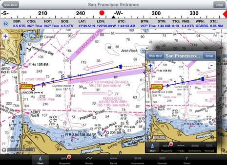
Whether you use Navionics or iNavX on your iPad, you have to get the various Seatalk output data from your instruments, GPS, AIS into a format that can be understood by either of those programs. That is exactly what you have to do to get the same information into an onboard computer. Typically, this is accomplished by a multiplexer which is spliced into the Seatalk network. Most of the data comes at a slow baud rate, but the data from an AIS is at a much faster rate. The multiplexer takes all of these data streams and sorts them out and sends them in a controlled output to the computer or if WiFi capable, to your iThing. But now, with MFD's having WiFi integrated, it takes the hassle out of setting up a WiFi multiplexer. Also, it is one less device to purchase, to get WiFi Looking at the video, RayControl also has some high bandwidth data displayed on your iThing. I'm impressed, and wonder what the other big manufacturers will bring to the market.
One last question. Does the new WiFi enabled e-series display integrate with iNavX for the data? I'm not expecting the chart to come across, but basic nmea 0183 sentences. Perhaps a reader will let us know.
I have taken a different approach. What do we use on our boat? We use a broadband (3G) wireless ( through cell towers) wifi, which can connect up to five devices on the boat. Most phone companies now sell these devices, but you can always put another (cell phone) companies sim card in if the device is unlocked. This is good for where ever there is cell phone coverage, although we carry two different provider devices, because we have come to realize that some cell phones coverage can vary depending where we are. Usually if we can't get service from one, the other will pick up. To complement this and increase our range, we use a cell phone booster, which can give us coverage up to 50 miles off shore. Take a look herefor what a cell booster can do for you. Finally, when we go to a different country, we go and buy their data sim and put it in our device, or buy their device depending how the country has set up their cellular data network. What do you use for internet?
Pop over to Chetco and have a look at their product range. I've only included a small fraction of what their stuff can do. Intergration of NMEA2000 and 0183 data and streamed wirelessly to your iThing. And a range of after market sensors. Here is a little of what they say and have available. Do go to their web site to get a bigger picture.
{ capture all of your engine data and control your switches }
SeaGauge™ Remote Sensor Interface Units (analog-to-digital converter box): Convert any engine data not provided by your standard ECM (engine controlmodule) to digital NMEA 2000 and/or NMEA 0183 compatible network data. View and control your data from any SeaGauge touch screen display unit, PC/Laptop, NMEA 2000 displays such as Garmin, Lowrance and Raymarine and iPad, iPhone, Tablet PC’s and a wide range of Smartphones {more}.
SeaSwitch™ Remote Switch Units: Our Remote Switch Units allow touch screen activation of a variety of equipment including NAV Lights, Bilge Pumps, Blowers, Running Light, SpotsLights, Cabin Lights, and much more. Switch Units provide reliable switching operation via any of the SeaGauge color touch panels or an attached PC/Laptop {more}.
{ view your live engine data in real-time, from any device }
SeaSmart.NET™ Wireless Modules: Our SeaSmart.NET modules allow all digital and analog data streaming through the NMEA 2000 or NMEA 0183 serial network to be sent to the onboard computer and routed over a local wireless internet server, or built in local intranet, where it can be accessed by multiple, authorized users, through any browser for real-time data display (with no additional apps needed). All data can be accessed locally (anywhere on the vessel with no outside connection to the internet needed) and/or remotely (for data sharing and logging data via the World Wide Web) from device, such as any smart phone, iPad, or laptop computer {more}.
{ manage from a single, ultra-bright, all weather LCD touch display }
SeaGauge™ All Weather Touch Screen Displays: Display and control your data with one of our high quality display units or with any existing NMEA 2000™ displays (such as Garmin, Lowrance and Raymarine). The user can view multiple instances of 16 function gauge clusters while controlling all of their switches, all from a single, ultra-bright, weather resistant, touch screen display unit {more}.
{ do it all, and much more }
The SeaPC™: A fanless and solid state PC computer with built in NMEA 2000™ and serial/USB adapters, and a 12V output in order to power your display using the PC. The SeaPC is optimized to run all of your gauges, switches, and engine log, while controlling your entire music and media center and browsing the Web, all from a single touch screen display. The SeaPC also allows the user to set-up a wireless network and view all of their digital NMEA 2000 data from multiple devices on the vessel, such as any smart phone, iPad, or laptop computer (without additional licensing fees or third party applications) {more}.
{ additional: Senders and Adapters }
Senders: We support a wide range of senders which measure every engine output from temperature to fuel flow using unique calibration tables that make it possible to match any desired range and unit of measure. Each unit is capable of measuring voltage, resistance, and pulses dependent on chosen sender type. Multiple pulse inputs allow a single gauge to be used for tachometer, speed, and fuel flow - all in one unit. Dual engine tachometers are standard on SeaGauge Sensor Interface Units. Senders are available in many different thread sizes and termination styles.
Adapters: Our adapters provided a range of networking options for all SeaGauge products. Most units have built-in Serial (RS232) and USB interfaces for direct connection to host PC/Laptops to allow configuration and display of instrumentation data, but our adapters allow for Bluetooth, WiFi or Ethernet options for all of your NMEA 0183, Serial or NMEA 2000 data.
I have shown elsewhere on this blog site, how a wireless multiplexer from Brookhouse, call an iMux, can be used to serve data to your iPad etc. Here is another similar device by Digital Yacht along with a couple of video's to help explain.
Digital Yacht's Description
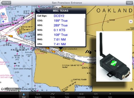
The world’s first wireless AIS receiver that links wirelessly with the latest iPhone, iPad and iTouch devices. Consisting of a high performance dual channel AIS receiver, an integrated 802.11b+g wireless access point plus a free app downloadable from the Apple App Store, the iAIS brings AIS data to a whole new generation of mobile devices.
iAIS also multiplexes any other NMEA data that is available on board the boat - for instance GPS, depth, speed and wind etc. All of this data is combined with the AIS data into a single wireless feed, that becomes available on any compatible application. By using the boat’s own GPS, even an iTouch or iPad that does not have an internal GPS can now be used for navigation and superior performance will also be seen on an iPhone, which some users have complained suffers from jitter or poor lock-on with its internal GPS.
As well as sending data wirelessly, the iAIS also has an NMEA0183 and USB interface so that you can output data to a PC (via USB) and a dedicated plotter (via NMEA) for larger installations.
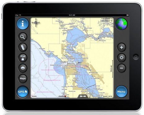
The free iAIS app is available from the App store and is a simple AIS display program. For more advanced use, Digital Yacht recommends the iNavX app (www.inavx.com). Compatible with Navionic’s charts, iNavX provides a complete set of navigation functions that turns your Apple device into a full function electronic chart plotter. It supports waypoints, routes and tidal data and is beautifully simple to use. It even overlays GRIB weather data. iNAVx sell and support this app directly and the cost is just $49.95 (click here).
Features;
World’s first wireless AIS and NMEA Data server
Tri-output; WiFi, NMEA 0183 and USB
Multiplexed NMEA input for wireless NMEA data feed of boat’s instrument and GPS data
Free iAIS App for iPhone, iTouch or iPad
Integrated 802.11b+g wireless access point
Fully compatible with popular iNavX navigation application for Apple mobile devices
Rugged IPX5 aluminium housing
Requires VHF antenna or dedicated AIS antenna (available as optional accessory) or splitter
Simple “fit and forget” black box solution
* NOTE - AIS target range, like VHF range is dependent upon a number of installation factors such as; antenna gain, antenna height and size of ground plane. Ranges in excess of 20-30 miles should be possible if all of these factors are perfect.
There is a multitude of sites through Google search which give excellent reviews and information about iNavX. Search and see for yourselves; but I'll place a few here; and there are links in the following information.
Try iNavX Review which has some great video tutorials.
Take a look at i-Marine Apps for their "Getting Started with iNavX.
And then take a look at the iPad holders from Zacor. And this waterproof casing here.
Finally link it all together with your electronics with an iMux as alluded to in a former blog or have it as a stand alone product with its own GPS from Badelf.
Here is a snopsis from iNavX themselves.......
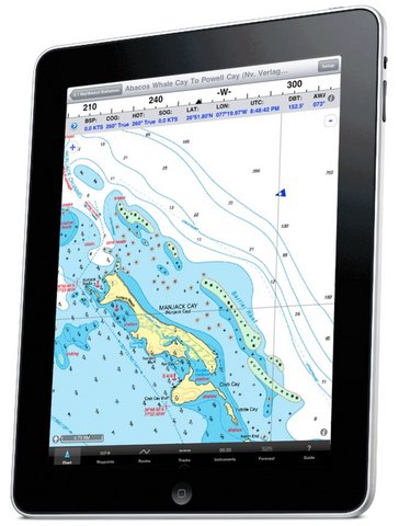
iNavX™ brings the freely available, official and up to date NOAA RNC raster United States waters marine charts to your iPhone, iPod touch and iPad. Included detailed chart coverage: West Coast, Gulf Coast, East Coast, Great Lakes, Alaska, Hawaii, and US Virgin Islands. One app for all your devices with access to thousands of charts and maps: official CHS Canada charts, Navionics Gold charts, Fish'N'Chip charts, HotMaps, NV. Verlag charts, Hilton's Fishing charts, TRAK Canada lakes fishing maps and Solteknik European waters charts may be purchased separately from X-Traverse.
With iNavX™ you can use the built in location services (i.e. GPS, cell tower, WiFi) to plot your position in real-time on the multi-touch scrolling and zooming and rotating (including course up) marine chart.
Using the iPhone's, iPod touch's and iPad's WiFi connection, iNavX™ can act as a repeater for popular marine navigation software that supports NMEA data over TCP/IP such as MacENC and Coastal Explorer. This includes GPS, AIS receivers & transponders, and Instruments (Depth, Speed, Wind, etc.)
In addition to real-time chart plotting and printing, iNavX™ supports waypoints & routes including KML (Google Earth) and GPX import/export, track log, measuring bearing/distance, GRIB weather forecast, tides/currents, anchor alarm, graphic instrumentation display and port/navaid search.
The power of a color chartplotter for a fraction of the cost. And Boaters.Com has this to say.....
In fact, the iNavX web site now boasts "The power of a color chartplotter for a fraction of the cost" and, while I'll stay out of that argument for the time being, developer Rich Ray does make a good case for how far he's taken the software, and how able it looks on the bigger iPad. Note, for instance, the series of screen shots comparing iNavX iPhone and iPad versions. Ray has also gotten his program to play nicely with a Digi Connect WI-SP WiFi serial server, which means you can get AIS and other NMEA 0183 data flowing to your iThing without any other computer involved (and he even added a Digi Connect guide to his extensive help files).
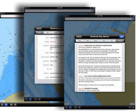
And if you want to use your spiffy iNavX/iPad combo with anything but free NOAA raster charts, you'll be pleased to know that X-Traverse keeps growing its already giant cartography portfolio, and adding to what the service can do (new Facebook integration, for instance, plus integration with Navionics NavPlanner 2). When you purchase charts via X-Traverse you get two activations, so if you're already using them on, say, an iPhone but haven't activated them with a PC or Mac, you're probably good to go if you get an iPad. The exception: Navionics is pricing its iPad charts differently -- understandable, I think, given how inexpensive their iPhone charts are, and their many partnerships with companies that manufacture those old time chartplotter things -- though $50 for the new U.S. super regionis not bad. That region includes the Northern Bahamas, by the way, but below is a sample of alternate NV charts of the same area, also offered by X-Traverse. Choices are good. And I'm not done... Navimatics has not only adapted its Charts & Tides program for the iPad, but expanded the included regions of NOAA ENC charts, lowered the price, and is just about to add support for ActiveCaptain! The implementation looks good on an iPad, too, as you can see below. As with MaxSea TimeZero 1.9 (just about to release!) and the Coastal Explorer 2010 beta, the ActiveCaptain data is cached so you still have it when not connected to the Internet. And we know Active Captain itself is also working on an iPad app. Damn.
i-Marine Apps tells us how to get additional charts through X-Traverse
If you want additional charts other than the free NOAA charts you can purchase these through X-Traverse. This process is complicated, so follow below.
You will need an X-Traverse account to purchase and access your charts. This account will cost you $10.00 per year and allows you access to your charts through the iNavX app. Access to Grib weather files and transfer of waypoints and tracks can also be done through your account.
Once you have your X-Traverse account you can then purchase additional charts. Make sure you purchase the iPad charts for download. They offer a wide range of Navionics, CHS Canadian Charts, Fish"N"Chips, HotMaps, NV Verlag and Hilton fishing charts.
To access and download your purchased charts in your iNavX app you need to add your X-Traverse account information to the app. Go to "Preferences" and select "X-Traverse Account". This is where you will add your email and password for your account.
Next select "Show Account Information" this will retrieve your account info showing you what products you have activated for use by the iNavX app.
You will next need to go back to the Charts list and select "Add More Charts to Menu". The next menu should show you the list of charts. The charts you purchased should show up as bolded. I purchased Navionics Gold Marine Charts 2011. Select this and another display will show the charts in that package. Turn "ON" the charts you purchased.
Go back to the iNavX menu and select the chart you turned on to view you charts. Select your chart title and download you your iPad.
iMarine Apps gives a good account of the Brookhouse iMux. I just might get one of these for the iPad which is sure to come one day. Read on...
Brookhouse iMux
What the heck is an iMux? Well, glad you asked. Mux is short for multiplexer and the i wirelessly connects your iPhone, iPad or iPod touch providing data from all your ships electronics and navigation hardware. This is truly a geeky item folks.
Brookhouse is run by a bunch of Kiwis from New Zealand. They have been around since 2002 providing solutions for integrating marine electronics on commercial and recreational yachts. A multiplexer combines many sources of NMEA 0183 data and creates a single stream of data that can be used by computers, chart plotters and other navigation devices. It takes data from any NMEA 0183 source such as, depth sounder, speed sensor, wind direction indicator, wind speed indicator, radar, weather station, GPS or fluxgate compass. I can them provide the data to any number of computers, laptops, smart phones, or tablet for use with navigation programs.
Features:
4 opto-isolated “NMEA Listener” (Input) ports, 3 at 4800 bps, 1 at 38400 bps for AIS.
1 RS232 output port for connection to a chart plotter or computer
Indicators: red LED for power, green LED for data-transmission.
Supply Voltage: DC 9-35 Volts.
Reversed polarity protection.
Physical size: 110x65x37mm (hxwxd)
Weight: 140 grams
Mounting: bulkhead mounting with screws.
NMEA management and control:
NMEA Sentence Filtering
NMEA Sentence editing “on the fly” for NMEA protocol conversion.
Automatic port switching.
This device is unique in that it does not require a computer to operate. So you can leave your laptop at home and wirelessly receive all your ships data on your iPad. The unit works great with the iNavx application and the Brookhouse website has alot of information on how to integrate an iMux into your ships systems and work with you iPad. iNavx is a great navigation and charting program which can be used on the iPad or iPhone.
Brookhouse has other multiplexers with USB and Bluetooth capabilities. Check out their website for the one that fits your needs. They do have a iMux-ST version which allows integration of SeaTalk data from your Raymarine instruments.
The people over at thewirie.com have come up with a great wifi product. Check it out!
The Wirie and The WirieAP Overview
Our products offer you the best combination of performance, ease of use, and durability on the market. Here is a summary of each product's features, click on the product name to learn more about The Wirie and The WirieAP.
Available now!
Now Available too!
• 1000mW WiFi Adapter (long-range)
• Single USB Cable installation (Max 79')
• 100% Marine Grade
• Fully waterproof (IP67)
• Flexible Mounting Options
• Portable (use on boat/RV and ashore)
• Requires a computer to operate
• WiFi Adapter upgradeable
• Simplest configuration, easiest to use
• Fully upgradeable to The WirieAP
• 8dBi Marine WiFi Antenna
• Choice of color
• 1 Year Warranty
• 1000mW WiFi Adapter (long-range)
• 500mW Local Access Point
• Provides onboard WiFi router for local network
• Single 12V Cable (No Max length)
• 100% Marine Grade
• Fully waterproof (IP67)
• Flexible Mounting Options
• Unlimited installation height
• No software installation
• Operate from any WiFi device
• 8dBi Marine WiFi Antenna
• Choice of color
• 1 Year Warranty